

UN General Assembly supported the transition to a world map with more accurate continent sizes
The UN General Assembly has approved a resolution on the use of maps that more accurately reflect the sizes of continents and do not distort the proportions of Africa. 164 states, including Uzbekistan, supported the initiative.
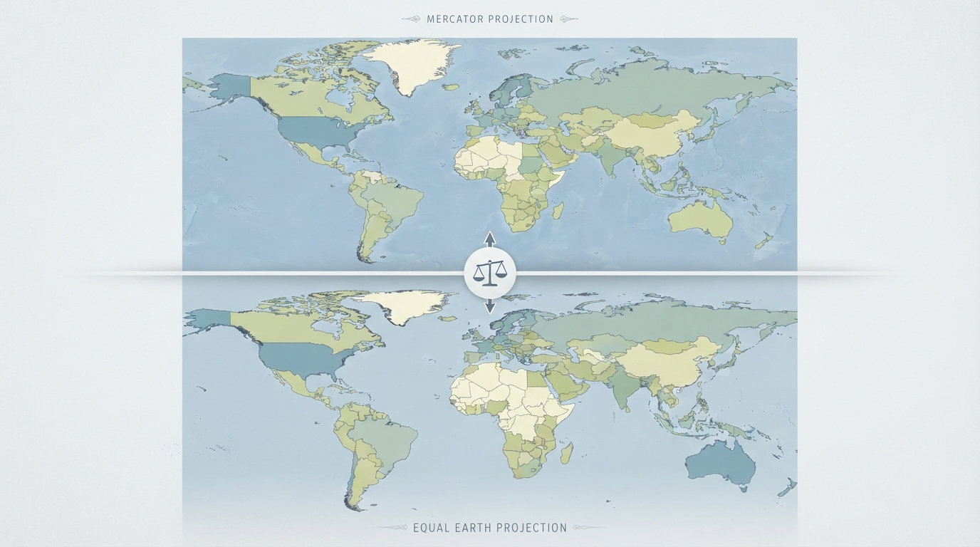
On September 4, the UN General Assembly approved a resolution on the use of maps that more accurately represent the sizes of continents, the UN News Service reports.
164 states voted in favor of the document, including Uzbekistan. Only the United States voted against. Six other countries — Estonia, Georgia, Lithuania, Moldova, Serbia, and Ukraine — abstained.
The initiative to replace traditional world maps came from African nations, led by Togo.
The resolution recommends that governments, schools, international organizations, and technology companies use the Equal Earth projection map and other equal-area maps in cases where it is important to consider the relative sizes of territories. At the same time, the document is advisory in nature and does not ban the Mercator projection.
Flemish cartographer Gerardus Mercator created his projection in 1569 for marine navigation. Straight lines on his map correspond to constant compass directions, allowing sailors to use them for plotting routes.
However, preserving directions came at the cost of distorting area. The further a territory is from the equator, the more it is enlarged. Greenland on such a map can appear roughly comparable in size to Africa, even though Africa is about 14 times larger. Northern Europe and North America also appear significantly enlarged compared to regions near the equator.
Despite its original navigational purpose, the Mercator projection is still widely used in educational, media, digital, and official materials.
The resolution notes that such distortions have contributed to the "symbolic diminution" of Africa and maintained an unbalanced view of the world.
Togo's Foreign Minister Robert Dussey emphasized that the resolution is not directed against the Mercator projection. "A fair map does not change the geography of the world — it changes how we see the world," he said.
The United States stated that the initiative is political in nature and called it part of a "much larger and more radical ideological project."
Ukraine, which abstained from the vote, stated that it supports efforts to correct historical distortions affecting Africa and other parts of the Global South, but expressed objections to how some maps using Equal Earth depict Ukrainian territories occupied by Russia.
The European Union supported the resolution but expressed similar concerns. Speaking on behalf of the EU, Ireland emphasized that this measure concerns only the relative sizes of territories and in no way affects issues of sovereignty, territorial status, or internationally recognized borders. The EU representative also stated that supporting the resolution does not imply automatic endorsement of the maps hosted on the Equal Earth website.