

“Super El Niño” and warm days. What will the weather be like in November? Weather forecast by Gazeta
In Uzbekistan, November is expected to be 1–1.5 degrees warmer than usual. However, there are differences between national and international forecasts regarding precipitation. How will the 'super El Niño' in the Pacific Ocean and Arctic processes affect the weather? Climatologist Erkin Abdulahatov shared his forecast for November with Gazeta.
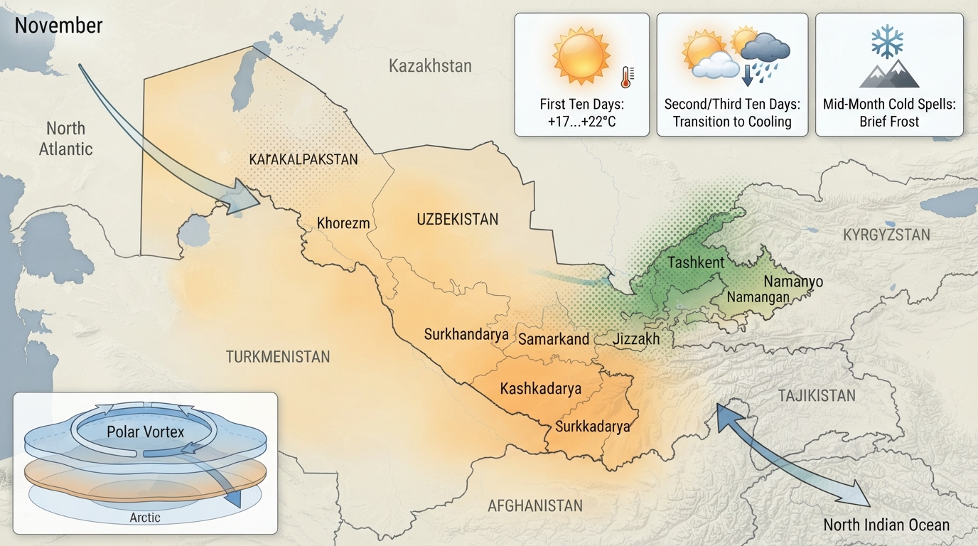
“Super El Niño” and warm days. What will the weather be like in November? Gazeta's forecast
The rapid warming of waters in the equatorial Pacific Ocean — El Niño — is accelerating quickly. At the end of October, water temperatures continued to rise excessively in the region of the Pacific Ocean where El Niño and La Niña are observed. Climatologist Erkin Abdulahatov shared the weather forecast for November with Gazeta.
In the past, similar ocean warming in the central Pacific, specifically during the corresponding periods of 1982–1983, 1997–1998, and 2015–2016, led to heavy precipitation during the autumn-winter seasons across much of the Central Asian region, including Uzbekistan. According to estimates by the National Oceanic and Atmospheric Administration, there is a 70 percent probability that El Niño will turn into a very strong event in November–January 2026.
Since such a process has not been observed for many years, it can be called a super El Niño. Based on this expectation, the World Meteorological Organization indicated in green that seasonal total precipitation for most of Central Asia, particularly Uzbekistan, may be above normal in the upcoming months of November, December, and January.
Although the World Meteorological Organization did not specify the exact deviation of precipitation from the norm for November in Uzbekistan — whether precipitation will be high, low, or normal — other international weather forecasting centers indicated that monthly precipitation in most of Uzbekistan could be above normal in November.
In its monthly forecast for November, the Uzhydromet agency predicted that precipitation across Uzbekistan would be normal or below normal. Uzhydromet drew attention to the fact that below-normal precipitation is expected in November in the Republic of Karakalpakstan, Khorezm, Navoiy, and Bukhara regions, as well as in large parts of the Samarkand, Jizzakh, and Surkhandarya regions. Normal precipitation was forecast for other areas.
Normal precipitation amounts for regions in November are expected to range from 8 mm to 60 mm; users can check the normal precipitation values for their residential areas on this forecast map.
Relying on the conclusions of the World Meteorological Organization and other international centers, Uzhydromet reported that in November, temperatures across most of Uzbekistan will be 1–1.5 degrees warmer than usual.
Under global climate change, particularly intense warming, November is expected to be warm in all regions of the world, and forecasts show this will also be observed in Uzbekistan. However, this does not mean there will be no cold waves during the month; on the contrary, it means that warm days will predominate over the 30 days of the month.
Therefore, without ruling out cold days in the temperature regime, we will witness a warm November where warm days prevail. Both Uzhydromet and other international forecasting centers unanimously confirm this. However, uncertainties regarding precipitation remain.
To fully answer these questions, we will focus on the current state of about five factors determining the transport of cold waves and moisture to Central Asia, as well as forecasts for the next 15 days and one month, to understand what the region's weather will be like and when cold waves might arrive.
The El Niño factor.
This factor remains a decisive driver in preparing long-term weather forecasts for the world. However, over the past two years, it has been observed that for Central Asian countries, El Niño does not produce the same autumn-winter precipitation deviations seen in past similar events. Climatologists attribute this phenomenon to the current conditions of climate change far from the region and the very unfavorable landlocked geographical location of countries like Uzbekistan. Nevertheless, with El Niño categorized as a super El Niño for the next three months, the warming of water in the central Pacific Ocean is giving positive signals for precipitation in the region.
Moisture in the North Atlantic.
This factor is a decisive driver of autumn-winter precipitation for Uzbekistan, and a large moist air stream known as the North Atlantic Oscillation remains in a position to bring significant rainfall to Uzbekistan this coming November. That is, it is expected to be in a negative phase, which brings dry days to Europe. This means that at least two or three moist air streams from the Atlantic Ocean will likely enter much of Uzbekistan in November. However, the issue lies in the precipitation capacity of these moist air streams. They are also directly affected by other processes.
Warming of water in the northern Indian Ocean.
It is not entirely correct to view this factor as a separate and direct mechanism that increases rainfall; however, in recent years, the impact of a phenomenon known as the Indian Ocean Dipole in the northern Indian Ocean has become somewhat significant in changing rainfall patterns to heavy downpours and intense precipitation in Uzbekistan.
At the beginning of November, it became clear that water temperatures in the northern Indian Ocean are warmer than normal, i.e., in a positive phase. This will likely ensure positive moisture capacity for regions of Uzbekistan other than the northern territories.
Temperature anomaly over the Arctic Circle and polar vortex speed.
These factors can be evaluated as determinants of early cold snaps in the region and the capacity of moisture coming from the west and south. This is because the southward shift of cold anticyclones and the dominance of such cold anticyclonic processes across much of Uzbekistan, leading to reduced moisture, are directly tied to temperature changes in the lower stratosphere at an altitude of 30 km above the North Pole and the large-scale vortex known as the polar vortex.
Currently, temperatures over the Arctic (at an altitude of 30 km) have risen significantly above normal, and the speed of constant winds blowing along the polar circle is slowing down sharply. This situation is expected to persist over the next two weeks.
This situation means that in mid-November and early December, the next cold anticyclone may penetrate deeper into Uzbekistan and significantly lower temperatures across the region.
However, this forecast and its fulfillment probability are not as high as usual. According to forecasts, starting from the third ten-day period of November, wind speeds in the polar vortex will strengthen again, reducing the likelihood of abnormal cold expectations in Uzbekistan in the second half of December and January.
Based on all the above signs and analog years similar to this year, we have compiled precipitation deviation maps for November.
According to Uzhydromet's advisory weather forecast for November, the first ten-day period will be relatively warm: nighttime temperatures will be +5…+10 degrees, and daytime temperatures will be +17…+22 degrees warm. In the second and third ten-day periods, temperatures will drop, fluctuating between −2…+3 degrees at night and +5…+20 degrees during the day.
The forecast map below shows that the monthly air temperature observed during the month will be 1–1.5 degrees higher than the long-term climatic norm in Kashkadarya, Surkhandarya, Samarkand, Jizzakh, Syrdarya, and Tashkent regions. This means that these specific regions will experience more warm days. Overall, the agency forecasts November temperatures to be significantly above normal. The monthly norm for November consists of temperatures ranging from zero to +13 degrees warm.
On certain days of the month, rain is possible, and during periods of lower temperatures, rain may briefly turn into snow. As mentioned above, Uzhydromet projected that November would pass with drier conditions against a backdrop of normal precipitation.
However, based on the five signs listed above, our forecast map compiled as an independent expert indicates that several moist air masses entering Uzbekistan could bring above-normal precipitation to certain regions.
In particular, precipitation in large parts of the Samarkand, Jizzakh, and Namangan regions, as well as the Tashkent and Syrdarya regions, may deviate up to 130 percent above the monthly norm, making November a wet month in these areas.
Karakalpakstan, Khorezm, and the Kyzylkum Desert are naturally low-precipitation regions. Since precipitation here in November is expected to reach only 70–90 percent of the norm, it can be assumed that the month will be dry in these areas. Precipitation is likely to occur mainly in the intervals between days in the first half of the month and during the third ten-day period. In some cases, precipitation is expected to fall locally as snow.
Thus, short-term cold spells are expected in the middle and at the end of the month. Additionally, except for the north and the Kyzylkum Desert, at least one moist air mass is projected to enter the republic and bring precipitation once every ten-day period.
Although repetitive, it is worth emphasizing once again that the reliability rate of long-term, specifically monthly and seasonal, weather forecasts is quite low. There are currently no methods capable of providing forecasts with an accuracy higher than 60–70 percent for each month during the autumn-winter season.