

The shadow becomes part of digital navigation: how Tashkent joined the global trend of climate-adaptive technologies
Uzbekistan has become one of the first countries where digital navigation has begun to take into account not only distance and travel time, but also the level of pedestrian comfort in hot weather conditions.
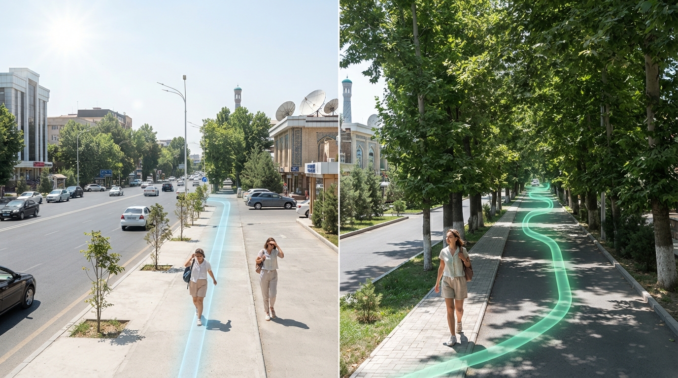
Shadow Becomes Part of Digital Navigation: How Tashkent Joined the Global Trend of Climate-Adaptive Technologies
Uzbekistan has become one of the first countries where digital navigation has begun to take into account not only distance and travel time, but also how comfortable it will be for a pedestrian to walk in the heat.
Urban navigation is gradually moving beyond its traditional task of showing the fastest or shortest path from one point to another. Against the backdrop of increasingly frequent periods of extreme heat, digital services are starting to consider another indicator — how comfortable it will be for a person to walk the route.
One such solution is the "green" routes in Yandex Maps, which were launched in Tashkent in pilot mode in August.
The new feature makes it possible to choose pedestrian routes with a higher proportion of shaded areas, thereby reducing the time spent under direct sunlight.
According to the international technology publication Techloy, Tashkent became the first city in Central Asia and the CIS where such a feature appeared in a mainstream mapping service. On a global scale, similar approaches are also being developed in the USA, Germany, and South Korea.
When Shadow Becomes Part of Urban Infrastructure
Typically, when assessing the quality of the urban environment, attention is focused on transport accessibility, road conditions, public transport, air quality, and the availability of public spaces. But climate change is forcing an expansion of this list.
In a hot city, trees and shaded pedestrian zones become not just an element of landscaping, but a factor in daily mobility.
For Tashkent, this issue is particularly significant. During the summer months, the air temperature often rises above 35–40°C, and even a relatively short walk can turn into a serious physical strain for a person.
Under such conditions, the digital map begins to play a new role: it not only helps to navigate in space, but also takes into account the climatic comfort of the route.
This approach reflects a broader global trend. In the spring and summer of 2026, various projects to find cool and shaded routes were developed in several countries.
In the US, Arizona State University is implementing the Cool Routes research project, aimed at finding cooler routes on campus. The National Shade Map shows the level of shade on streets in hundreds of US cities, although it does not plot routes directly.
In Germany, the HEAL (Heat Adaptation for Vulnerable Population Groups) project is being developed, aimed, among other things, at protecting population groups most susceptible to the effects of high temperatures. In South Korea, the local app Geuneullo offers users walking routes with the maximum amount of shade.
Thus, Tashkent has become part of an emerging international direction — climate-adaptive navigation.
How the "Green" Route Works
The technological feature of the new solution is that the algorithm analyzes not only the street map, but also the characteristics of the vegetation cover.
The technology is based on machine learning and satellite image analysis. The algorithm recognizes tree canopies from multispectral data and estimates what portion of the pedestrian path passes under vegetation.
At the same time, it is not enough to simply determine how "green" an area looks as a whole.
An individual section of a route is considered green if trees cover at least 60% of its length. In addition, the algorithm analyzes the distribution of shade along the route and the duration of a person's stay under the open sun.
Another parameter is the air temperature typical for a specific day and time.
Thus, the route is actually evaluated by several criteria at once: the length of shaded sections, their distribution, the time spent in the sun, and temperature conditions.
This is fundamentally different from conventional navigation, where the main criteria remain distance, time, and road accessibility.
Why Satellite Data in Particular
In international practice, different methods are used to build routes taking shade into account.
They can be roughly divided into three approaches: geometric, biophysical, and satellite.
The satellite approach allows for the direct assessment of vegetation cover over large areas. For a large city, this is particularly important: it is practically impossible to manually determine the condition of every tree or the degree of shade on every street.
The use of satellite images and machine learning algorithms makes it possible to regularly process large volumes of spatial data and turn them into information understandable to the average user.
As a result, the complex technology becomes almost invisible: a person simply chooses a suitable pedestrian route in the application.
Heat is Changing the Perception of Mobility
The emergence of such services cannot be viewed merely as a technological novelty.
It reflects a change in the very approach to urban mobility. Previously, the most efficient route was considered to be the one that allowed a person to reach their destination faster. Now, in a hot climate, an additional question arises: which route will allow this to be done with less physical strain.
This can be especially important for people sensitive to high temperatures, elderly citizens, children, and those who have to walk a lot.
Global interest in such solutions is intensifying against the backdrop of changing temperature regimes. According to the Copernicus Climate Change Service, the average temperature in Western Europe in June–July 2026 reached 21.62°C, which is about 2.8°C above normal, and in Spain, Portugal, and France, temperatures repeatedly exceeded 40°C.
This shows that adapting cities to heat is becoming an international task, and digital technologies are gradually turning into one of the tools for its solution.
Technology Does Not Replace Greenery — It Helps Unlock Its Potential
At the same time, digital navigation is not a substitute for real urban greening.
The algorithm can show a person where there is already shade, but it cannot replace the trees, parks, and green corridors themselves. In this sense, "green" routes can be viewed as a kind of digital layer over the existing urban infrastructure.
The more trees and continuous green routes there are in a city, the more opportunities there are to create a comfortable pedestrian network.
Therefore, such technologies could potentially be important for urban planning as well. Data on popular shaded routes could in the future be used to identify areas where new trees, canopies, recreation areas, or other elements of climate adaptation are particularly needed.
In other words, a digital map can not only reflect the urban environment, but also help to better understand its needs.
Tashkent as a Platform for Climate Innovation
For Uzbekistan, the introduction of such technology is of particular interest.
Tashkent is a large and rapidly developing city with a high density of transport and pedestrian flows.
At the same time, it faces high summer temperatures characteristic of a continental climate.
Under these conditions, a combination of greening, public transport development, the creation of comfortable pedestrian spaces, and digital tools can become part of a more comprehensive strategy for adapting the urban environment.
The launch of "green" routes shows that climate adaptation is gradually moving from the sphere of exclusively large infrastructure projects into everyday digital services.
A person may not think about the city's climate policy, but can use its results daily — by choosing a shadier route to work, a shop, a park, or a public transport station.
From a Digital Map to a "Smart" City
In a broader context, the emergence of climate-adaptive navigation is another step towards the formation of a smart city, where digital services take into account not only spatial characteristics, but also the real living conditions of a person.
The next stage in the development of such solutions could be a deeper integration of data on temperature, air quality, greening, street congestion, and public transport accessibility.
Then the digital map will turn from a navigation tool into a kind of interface of the urban environment — a system that helps a person make decisions taking into account not only speed, but also health, safety, and comfort.
For Tashkent, the appearance of "green" routes in this sense has a symbolic meaning. The city is becoming a participant in a global technological experiment in which shadow is transformed from a natural element of the urban environment into a digital navigation parameter.
And this is perhaps one of the most visual examples of how climate change is gradually changing even the most familiar technologies — right down to how a digital map shows a person the way.